


Map of the Week: Upande’s Virtual Kenya
[Editors Note: Earlier this month we lauched morethanamap.com to showcase the unique features of the Google Maps API. As part of this project, each week we’ll be featuring one story from our global community of developers who are using the Google Maps API to start businesses, help improve their communities or save the environment.]
This week we move on from Bangkok to Nairobi where we met with the Upande Ltd team at their office in the home of Mark de Blois. Upande is a development shop in Nairobi, Kenya that provides web mapping and GIS solutions expertise to a diverse range of enterprise, NGO, and public sector clients. Although Upande is relatively small (about 10 employees at the time of our visit), the tightly knit team is creating a big impact around the world with the Google Maps and Google Earth powered Virtual Kenya project.
Virtual Kenya is an online interactive platform designed to allow more Kenyans to use and interact with spatial data in both educational and professional pursuits. Users can view, download, publish, share, and comment on various maps covering topics such as water sanitation, wildlife, or politics. According to Upande the goal of the Virtual Kenya project is to, “promote increased data sharing and spatial analysis for better decision-making, development planning and education in Kenya, while at the same time demonstrating the potential and use of web-based spatial planning tools."
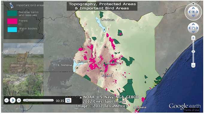
A big part of Virtual Kenya is making the data interactive and visually exciting, while also easy to access. To do this the Upande team uses the Google Earth API which allows them to use 3D map visualization directly on the site. In the screenshot above is an interactive tour that describes Kenya's tourism sector guided by Google Earth. This tour focuses on major attractions, national parks, environmental challenges, and areas that could be used to improve the industry. The full list of Virtual Kenya’s tours cover a variety subjects, such as deforestation, population issues, and threats to wildlife. Beyond the tours, there’s also a list of more Google Maps based mashups that help users learn more about a variety of subjects such as the Turkana Oil Fields, water quality, and aspiring politicians.
In the video below, Upande geo engineer Bernadette Ndege gives a live demonstration of how Virtual Kenya works.
Many thanks to the Upande team for inviting us into their office and sharing with us their latest projects. To learn more about Upande and the things that you can do with the Google Maps API, visit morethanamap.com. You can also see more pictures from our visit to Upande on Google+. Tune in next week to read about our visit with Ubilabs in Hamburg, Germany.
====
Carte de la semaine : Virtual Kenya selon Upande
[Note de l'éditeur : Ce mois-ci, nous avons lancé l'application morethanamap pour présenter les fonctionnalités de Google Maps API. Dans le cadre de ce projet, chaque semaine, nous vous proposerons un article sur la communauté mondiale de développeurs qui utilisent Google Maps API pour créer des entreprises, contribuer à l'amélioration de leurs communautés ou préserver l'environnement.]
Cette semaine nous quittons Bangkok pour rejoindre Nairobi où nous avons rencontré l'équipe d'Upande Ltd dans ses bureaux, sur les terres de Mark de Blois. Upande est une société de développement installée à Nairobi, au Kenya, qui offre son expertise en matière de solutions de cartographie web et GIS à un large éventail d'entreprises, d'ONG et de clients du secteur public. En dépit de sa taille relativement modeste (nous avons rencontré une dizaine employés lors de notre visite), l'équipe très soudée d'Uplande fait un travail dont les retombées ont un impact important dans le monde entier à travers le projet Virtual Kenya soutenu par Google Maps et Google Earth.
Virtual Kenya est une plateforme interactive en ligne qui permet à un nombre croissant de Kenyans d'exploiter les données spatiales dans des applications à la fois pédagogiques et professionnelles. Les utilisateurs peuvent ainsi visualiser, télécharger, publier, partager et commenter différentes cartes couvrant des thèmes aussi variés que l'assainissement de l'eau, la faune et la flore sauvages ou la vie politique. Selon Upande, le projet Virtual Kenya a pour objet de « promouvoir le partage de données et l'analyse spatiale pour faciliter le processus décisionnel, développer la planification et l'éducation au Kenya, tout en démontrant le potentiel et l'utilité des outils de planification spatiale basés sur le Web. »
La mission principale de Virtual Kenya consiste à rendre ces données interactives, visuellement attractives et faciles d'accès. L'équipe d'Upande utilise pour cela Google Earth API qui lui permet d'appliquer directement sur le site la visualisation sur carte en 3D. La capture d'écran ci-dessus illustre un circuit interactif qui décrit le secteur du tourisme kenyan à l'aide de Google Earth. Ce circuit met l'accent sur les principales attractions, les parcs nationaux, les défis environnementaux et les domaines qui pourraient être exploités pour améliorer ce secteur d'activité. La liste complète des circuits Virtual Kenya couvre différents thèmes, par exemple la déforestation, les questions démographiques , ou les menaces sur la faune et la flore. L'application comporte également d'autres appli composites (Mashup) basés sur Google Maps qui permettent aux internautes d'en savoir plus sur toute une variété de thèmes tels que les champs pétrolifères de Turkana, la qualité de l'eau et les candidats à la vie politique.
Dans la vidéo ci-dessous, Bernadette Ndge, ingénieur géographe chez Upande, fait une démonstration en direct du fonctionnement de Virtual Kenya.
Nous remercions vivement l'équipe d'Upande de nous avoir accueillis dans ses bureaux pour nous faire part de ses tout derniers projets. Pour en savoir plus sur Upande et sur les applications de Google Maps API, visitez le site morethanamap.com. Vous pouvez également retrouver toutes les photos de notre visite chez Upande sur Google+. Ne manquez pas notre rendez-vous de la semaine prochaine pour tout savoir sur notre visite chez Ubilabs à Hambourg en Allemagne.
Publié par Carlos Cuesta, Product Marketing Manager, Google Maps API


0 comments:
Post a Comment