


On July 9, South Sudan will officially be independent, becoming Africa’s 54th state.
In anticipation of this significant development, the World Bank, UNOSAT, RCMRD, Satellite Sentinel Project and Google organized a South Sudan Community Mapping event in Nairobi on June 30. This was the second in a series of mapping events intended to encourage local people to create accurate and detailed maps of South Sudan, to help them navigate their path to independence. There were over 100 attendees in the room, mostly Sudanese -- university students, humanitarian workers, journalists, developers, donors, citizens -- coming from Nairobi and its surroundings, but also as far as Juba, the capital of South Sudan.
The lives of the South Sudanese are anchored to their history and land. The event started with the sharing of prayers, stories and songs, allowing each of us to visualize the rivers, sheep, roads, and people. Drawn from these songs, the mapping of South Sudan with Google Map Maker began. I was excited to see schools, roads, rivers, historical monuments, and cemeteries being mapped over cities such as Aweil, Boma, Bor, Malakal, Rumbek, Tonga, Torit, and more.
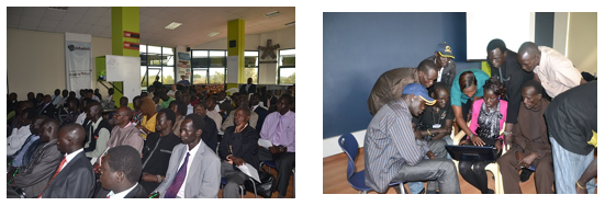 |
Community Mapping Event in Nairobi on June 30, 2011 |
The openness and enthusiasm of Sudanese attendees to map their new country was inspiring. Many were interested in health resource mapping which can dramatically impact the lives of their new countrymen. Every year in South Sudan about one in every seven children dies before the age of five; the maternity mortality rate is one of the highest in the world, and only 30% of the population has access to health care. For Charles Mona, Director GIS, Remote Sensing & Cartography of the South Sudan Government, quality health resource maps would be great tools for improved health care planning, resource allocation, advocacy, and also increased access to health services for the local population. This is only one example of how accurate maps can help various organizations provide better services to the the South Sudanese.
Happy independence day to the South Sudanese! Together, let’s continue mapping, and stay connected via our Sudan-specific email discussions. The next Community Mapping event will be in Juba, so stay tuned for more details.
====
Les chants accompagnent la cartographie de Sud-Soudan
Le Sud-Soudan se prépare au changement et à l'indépendance, car il sera officiellement le 54e État africain le 9 juillet.
Pour anticiper cette situation, la Banque Mondiale, UNOSAT, RCMRD, Satellite Sentinel et Google ont organisé, à Nairobi le 30 juin, un événement sur la cartographie du Sud-Soudan par la communauté. C'est le second d'une série d'événements de cartographie conçus pour encourager la population locale à créer des cartes précises et détaillées du Sud-Soudan et l'aider à avancer sur le chemin de l'indépendance. Plus de 100 participants, essentiellement soudanais, étaient présents dans la salle. Il s'agissait surtout d'étudiants, de travailleurs humanitaires, de journalistes, de développeurs, de donateurs et de citoyens venus de Nairobi et de ses environs, et même de Juba, la capitale du Sud-Soudan.
La vie des Sud-soudanais est ancrée dans leur histoire et leur terre. L'événement a démarré par des prières, des histoires et des chants, qui ont permis à chacun de nous de visualiser les rivières, les moutons, les routes et les gens. La cartographie n'a démarré qu'après cela, utilisant Google Map Maker. J'étais impatient de voir les écoles, routes, rivières, monuments historiques et cimetières cartographiés sur des villes comme Aweil, Boma, Bor, Malakal, Rumbek, Tonga, Torit et d'autres encore.
L'ouverture et l'enthousiasme des participants soudanais pour la cartographie de leur nouveau pays ont été fantastiques. Ils étaient nombreux à être intéressés par la cartographie des ressources médicales au Sud-Soudan, sachant qu'un enfant sur sept meurt avant l'âge de cinq ans. Le taux de mortalité des femmes enceintes est l'un des plus élevés au monde et seulement 30 % de la population a accès aux soins médicaux. Une carte précise des ressources médicales aurait d'ailleurs été utile à l'un des participants pour situer l'hôpital le plus proche lorsqu'un de ses collègues a été victime d'un regrettable accident dans la campagne du Sud-Soudan. Pour Charles Mona, directeur GIS, division télédétection et cartographie, du gouvernement du Sud-Soudan, ce type de cartes de qualité serait un outil extraordinaire pour améliorer l'organisation des soins médicaux et l'attribution des ressources, favoriser la défense de certaines causes et augmenter l'accès aux soins médicaux de la population.
Nous attendons impatiemment le jour de l'indépendance pour les Sud-soudanais! Ensemble, nous allons poursuivre la cartographie et rester connectés via nos discussions par email propres au Soudan. Le prochain événement de cartographie par la communauté se déroulera à Juba, alors restez connecté pour en savoir plus!


0 comments:
Post a Comment